
Do you want to know if your friends are okay? Were they in the path of dangerous storms? Are firefighters battling a wildfire near them? Did you learn of an earthquake in an area that will change your travel plans? I tracked down some tools that might help you navigate natural disasters. I’ll share a lot of screenshots of the sites.
Online Disaster-tracking Tools
Google Maps
I noticed last year that Google Maps has “natural disaster icons.” I saw a wildfire icon near my brother’s town. I also constantly checked a hurricane’s exact position as it swirled closer to our home.
This past March, I was concerned about a friend caught in a historic snowstorm in the San Bernardino mountains. Here’s my screenshot of the road closures taken during that time:

I wasn’t aware that clicking on “Southern California winter storm” would’ve opened more information in a sidebar.
To write this post this morning, I discovered a tornado warning in Dothan, Alabama. This time, I clicked on the icon. I could see the sidebar and what area was under the tornado warning.

I wondered how I could find out about the recent tornados of the past several weeks. Mississippi. Alabama. California. Iowa. Delaware. I know people in all these states.
- The University of Michigan has a map of tornado activity for the past 48 hours only.
- The Weather Channel’s Tornado Central has recent stories and videos of tornadoes. Click back in time to find an area you’re concerned about.
- For specific details of all touchdowns, as well as global disasters, visit the Center for Disaster Philanthropy.
- For real-time forecasting, visit USTornados.com or Tornado HQ.
Wildfires

One summer, the air quality was very bad in Minnesota and Iowa because of the massive California wildfires. I had to cancel my trip.
- The screenshot is of the Fire and Smoke map from AirNow, a government site.
- The Fire, Weather, & Avalanche Center’s map is very detailed.
Other sites
Many of these maps are global maps.
- Facebook provides “I am safe” pages for disasters. I’m sure you’ve already seen these “Crisis Responses” in your Facebook news feed. See “How to mark Yourself Safe on Facebook” from Lifewire for more information about this feature.
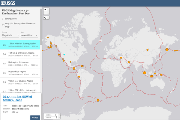
- The United States Geological Survey (USGS) has “event notifications” for current earthquakes and tsunamis on their homepage. Find an earthquake section deeper on the site. The screenshot is their map of current earthquake activity. I clicked on the dot for Stanley, Idaho.
- The USGS has a map for the Volcano Hazards Program. Kilauea is still on advisory status.
- The NOAA, our national weather service, has the U.S. Tsunami warning system map and an interactive flooding map.
- The National Hurricane Center is my go-to for Western Hemisphere hurricanes.
- The NOAA Storm Prediction Center includes storms, tornadoes, and fire weather outlook.
- I already mentioned the Center for Disaster Philanthropy, reporting on global disasters, including landslides and avalanches.
- Eighteen countries provide content for Google’s Public alerts. Follow their links to find out weather and disaster information from these countries.
Contact Your Friends
If your ministry partner is in a disaster area, they may not have power or phone coverage or mail service. They may not have the time to respond on social media or to answer an email or a phone message. Depending on your relationship with them, try these, of course. Determine the best and most meaningful way to contact them. You may want to do more than communicate with them, of course.
If they did suffer damage or loss, don’t forget them. It takes months, and even years, to recover from disasters.
Take some time to reach out to your friends and ministry partners!
Pin me, please

Tornado photo by Nikolas Noonan on Unsplash
